Portable Message Signs on I-17 to Help Drivers Avoid Delays
PHOENIX, ARIZONA, USA – To help drivers avoid delays approaching an Interstate 17 work zone south of downtown Phoenix, the Arizona Department of Transportation (ADOT) is using portable message signs that display travel times for the optional Interstate 10 route that can save commuters several minutes.
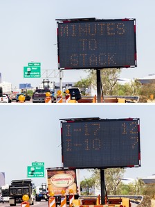
The electronic signs, located on trailers, show estimated travel times for I-17, where the freeway is narrowed for bridge reconstruction at Central Avenue, as well as travel times for I-10 between the “Stack” interchange and the “Split” near Phoenix Sky Harbor International Airport.
According to a press release, the I-10 detour route in the downtown area recently has been saving drivers at least 5 minutes compared to the stretch of I-17 where the bridge over Central Avenue is being reconstructed. I-17 traffic is limited to two lanes in each direction in that area.
Signs are located along westbound I-10 approaching the I-17 Split near the airport as well as along southbound I-17 and eastbound I-10 in areas approaching the Stack.
ADOT arranged for use of the electronic signs while planning for the $13.5 million bridge project at Central Avenue. Work to reconstruct the bridge started in May and is scheduled for completion in fall 2021.
The portable sign system uses traffic data to calculate the estimated travel times to predetermined destinations, much like on most permanent message boards along Valley freeways.
As part of the “Smart Work Zones” pilot project, portable message boards also have been placed in areas along I-10 approaching interchanges connecting to the new Loop 202 South Mountain Freeway. Those signs also provide drivers with estimated travel times for using either Loop 202 or I-10 through the downtown Phoenix region.
¡Gracias por leer a The Border Reports!
Ailun 3 Pack for iPhone 17 Pro Max Privacy Screen Protector [6.9 inch]+ 3 Pack Camera Lens Protector with Installation Frame,Dynamic Island Compatible,Anti Spy Tempered Glass[9H Hardness]-HD
$7.88 (as of abril 3, 2026 21:59 GMT -04:00 - More infoProduct prices and availability are accurate as of the date/time indicated and are subject to change. Any price and availability information displayed on [relevant Amazon Site(s), as applicable] at the time of purchase will apply to the purchase of this product.)
UNBREAKcable 2-Pack Screen Protector for iPhone 16, Double Shatterproof Tempered Glass [Easy Installation Frame] [9H Hardness] [99.99% HD Clear] [Case Friendly] for Apple iPhone 16 6.1 inch
$13.59 (as of abril 3, 2026 21:59 GMT -04:00 - More infoProduct prices and availability are accurate as of the date/time indicated and are subject to change. Any price and availability information displayed on [relevant Amazon Site(s), as applicable] at the time of purchase will apply to the purchase of this product.)
Apple AirPods Pro 3 Wireless Earbuds, Active Noise Cancellation, Live Translation, Heart Rate Sensing, Hearing Aid Feature, Bluetooth Headphones, Spatial Audio, High-Fidelity Sound, USB-C Charging
$180.05 (as of abril 3, 2026 21:59 GMT -04:00 - More infoProduct prices and availability are accurate as of the date/time indicated and are subject to change. Any price and availability information displayed on [relevant Amazon Site(s), as applicable] at the time of purchase will apply to the purchase of this product.)
Apple AirTag (2nd Generation): Tracker for Keychain, Wallet, and More; Locator with Sound; Simple One-Tap Setup with iPhone or iPad; Key Finder with up to 1.5X Precision Finding Range
$42.00 (as of abril 3, 2026 21:59 GMT -04:00 - More infoProduct prices and availability are accurate as of the date/time indicated and are subject to change. Any price and availability information displayed on [relevant Amazon Site(s), as applicable] at the time of purchase will apply to the purchase of this product.)
Ailun Privacy Screen Protector for iPhone 17e / iPhone 16e / iPhone 14 / iPhone 13 / iPhone 13 Pro [6.1 Inch] 2 Pack Anti Spy Private Tempered Glass Case Friendly [Not for iPhone 16 6.1 Inch]
$6.98 (as of abril 3, 2026 21:59 GMT -04:00 - More infoProduct prices and availability are accurate as of the date/time indicated and are subject to change. Any price and availability information displayed on [relevant Amazon Site(s), as applicable] at the time of purchase will apply to the purchase of this product.)
Beats Solo 4 - Wireless On-Ear Bluetooth Headphones, Up to 50-Hour Battery Life, Ultra-Lightweight Comfort, Powerful and Balanced Sound, Apple & Android Compatible - Matte Black
$100.64 (as of abril 3, 2026 21:59 GMT -04:00 - More infoProduct prices and availability are accurate as of the date/time indicated and are subject to change. Any price and availability information displayed on [relevant Amazon Site(s), as applicable] at the time of purchase will apply to the purchase of this product.)
NEW'C 3 Pack Designed for iPhone 17, 17 Pro, iPhone 16 Pro Screen Protector (6.3 inches), Enhanced Tempered Glass Protection with easy installation tool included,Case Friendly Ultra Resistant
$5.30 (as of abril 3, 2026 21:59 GMT -04:00 - More infoProduct prices and availability are accurate as of the date/time indicated and are subject to change. Any price and availability information displayed on [relevant Amazon Site(s), as applicable] at the time of purchase will apply to the purchase of this product.)
JBL Vibe Beam 2 - True Wireless Noise Cancelling Earbuds with JBL Pure Bass Sound & Smart Ambient technology, 4mics for crisp, clear calls, up to 40Hrs of Playback, IP54 Dust & Water resistant (Black)
$35.00 (as of abril 3, 2026 21:59 GMT -04:00 - More infoProduct prices and availability are accurate as of the date/time indicated and are subject to change. Any price and availability information displayed on [relevant Amazon Site(s), as applicable] at the time of purchase will apply to the purchase of this product.)
Ailun 3 Pack Screen Protector for iPhone 17 Pro Max [6.9 inch] with Installation Frame, Tempered Glass, Sensor Protection, Dynamic Island Compatible, Case Friendly
$6.98 (as of abril 3, 2026 21:59 GMT -04:00 - More infoProduct prices and availability are accurate as of the date/time indicated and are subject to change. Any price and availability information displayed on [relevant Amazon Site(s), as applicable] at the time of purchase will apply to the purchase of this product.)
Amazon Basics microSDXC Memory Card with Full Size Adapter, A2, U3, Read Speed up to 100 MB/s, 128GB, Black
$25.35 (as of abril 3, 2026 21:59 GMT -04:00 - More infoProduct prices and availability are accurate as of the date/time indicated and are subject to change. Any price and availability information displayed on [relevant Amazon Site(s), as applicable] at the time of purchase will apply to the purchase of this product.) Apple AirTag (2nd Generation): Tracker for Keychain, Wallet, and More; Locator with Sound; Simple One-Tap Setup with iPhone or iPad; Key Finder with up to 1.5X Precision Finding Range
$42.00 (as of abril 3, 2026 21:59 GMT -04:00 - More infoProduct prices and availability are accurate as of the date/time indicated and are subject to change. Any price and availability information displayed on [relevant Amazon Site(s), as applicable] at the time of purchase will apply to the purchase of this product.)
charmast Portable Charger with Built in Cables, Power Bank with Cords Wires, Slim 10000mAh Travel Battery Pack 6 Outputs 3 Inputs 3A Fast Charging for Samsung Google Pixel LG Moto iPhone iPad
$29.99 (as of abril 3, 2026 21:59 GMT -04:00 - More infoProduct prices and availability are accurate as of the date/time indicated and are subject to change. Any price and availability information displayed on [relevant Amazon Site(s), as applicable] at the time of purchase will apply to the purchase of this product.) Ailun Privacy Screen Protector for iPhone 17e / iPhone 16e / iPhone 14 / iPhone 13 / iPhone 13 Pro [6.1 Inch] 2 Pack Anti Spy Private Tempered Glass Case Friendly [Not for iPhone 16 6.1 Inch]
$6.98 (as of abril 3, 2026 21:59 GMT -04:00 - More infoProduct prices and availability are accurate as of the date/time indicated and are subject to change. Any price and availability information displayed on [relevant Amazon Site(s), as applicable] at the time of purchase will apply to the purchase of this product.)